DAY 3:
THE SCIENCE OF INDUSTRY
PROJECT MISSION

The Lesson Mission is what you (the student) will be able to do after the lesson is over.
DIRECTIONS: Today, you will not write your Lesson Mission. You will do a week long project to demonstrate that you have completed the mission.
The Lesson Mission for today is: I can describe the geography and economy of the Gulf Coastal Region during and just after the Reconstruction Era and explain how different things effected the economy and culture of the region.
TODAY'S ASSIGNMENT

DIRECTIONS: Read today's reading about the science involved in the Seafood Industry of the Gulf Coast Region. Then work on your magazine page. To stay on schedule, you need to read the article and create today's page by the end of the day.
The Gulf Region has many coastal or marine wetlands. Coastal wetlands are any land that is flooded or submerged during the average high tide. So the tide makes them a wetland.
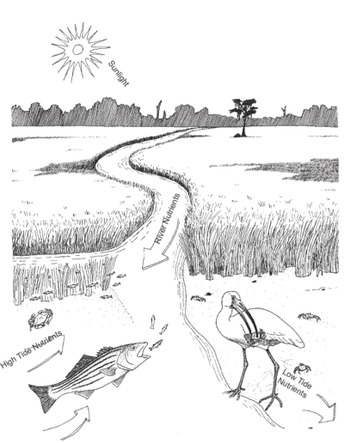
As the tides rise and fall, nutrients are exchanged between the different types of coastal wetlands. Small, broken pieces of nutrient - rich plant and animal material, called detritus, are washed out of the marshes into the nearby waterways and vice versa. These bits of food are eaten by bacteria and small animals which are, in turn, eaten by larger animals.
As the tides rise and fall, nutrients are exchanged between the different types of coastal wetlands. Small, broken pieces of nutrient - rich plant and animal material, called detritus, are washed out of the marshes into the nearby waterways and vice versa. These bits of food are eaten by bacteria and small animals which are, in turn, eaten by larger animals.
There are several Gulf Coast Wetlands. The main two main types of Gulf Coast Wetlands are Salt Marshes and Swamps.
Salt Marshes
The northeast Gulf of Mexico shoreline contains about 60 percent of the coastal and freshwater marshes in the United States.
WHAT ARE SALT MARSHES?
Salt marshes are coastal wetlands found throughout the world on shorelines and on the edges of estuaries where freshwater mixes with seawater. An estuary is a partially enclosed body of water where freshwater from rivers and streams mixes with salt water from the ocean.
Salt marshes are transitional zones between the aquatic and terrestrial world. Further up the estuary there is a transition to fresh water marshes that are affected by tides, and still further up are non-tidal fresh water marshes. In the upper parts of estuaries where the salt water is more diluted with fresh water, they are referred to as “brackish” marshes.
Salt marshes are transitional zones between the aquatic and terrestrial world. Further up the estuary there is a transition to fresh water marshes that are affected by tides, and still further up are non-tidal fresh water marshes. In the upper parts of estuaries where the salt water is more diluted with fresh water, they are referred to as “brackish” marshes.
LOCATIONS OF SALT MARSHES ON THE GULF OF MEXICO
|
|
TYPES OF SALT MARSHES ON THE GULF OF MEXICO
|
|
ANIMALS IN SALT MARSHES ON THE GULF OF MEXICO
|
Invertebrates
|
Vertebrates
|
|
Reptiles
|
Birds
|
|
|
Mammals
|
|
PLANTS IN SALT MARSHES ON THE GULF OF MEXICO
Very few plants can grow in saline areas that a prone to flooding. Two main grasses are usually found in salt marshes
- Smooth cordgrass
- Needlerush
Swamps
Florida's southwest coast supports one of the largest mangrove swamps in the world. Development has destroyed much of the mangrove forests in Florida, so now they are protected. It is illegal to remove mangroves from the shoreline.
WHAT ARE SWAMPS?
A swamp is an area of land that is always wet and mushy if not completely covered with water. Swamps are dominated by trees. They are often named for the type of trees that grow in them. There are freshwater and saltwater swamps. Saltwater swamps are the major type that line the Gulf Coast line, however, there are freshwater swamps near the coastline as well. One famous freshwater swamp near the coastline is called the Everglades in the state of Florida. Swamps are transition areas. They are neither totally land nor totally water.
LOCATIONS OF SWAMPS ON THE GULF OF MEXICO
|
|
Well-Known Cypress Swamps:
- Big Cypress Swamp
- Okefenokee Swamp
TYPES OF SWAMPS ON THE GULF OF MEXICO
|
Saltwater Swamps
|
Freshwater Swamps
|
ANIMALS IN SWAMPS ON THE GULF OF MEXICO
Mangrove Swamp Animals
|
Invertebrates
|
Vertebrates
|
|
Reptiles
|
Birds
|
|
|
|
|
Mammals
|
|
Cypress Swamp Animals
|
Invertebrates
|
Vertebrates
|
|
Reptiles
|
Amphibians
|
|
Birds
|
Mammals
|
PLANTS IN SALT MARSHES ON THE GULF OF MEXICO
|
|
THE GULF
What Is the Gulf of Mexico?
A gulf is a large body of the ocean that is partly surrounded by land. The Gulf of Mexico's ecosystem provides the United States with abundant seafood, valuable energy resources, extraordinary beaches and leisure activities, and a rich cultural heritage. As the ninth largest water body in the world, the Gulf of Mexico teems with sea life, from shrimp to unexplored deep-water corals living thousands of feet below the surface. Its coastal areas contain half the wetlands in the United States and are home to vital natural resources, including nesting waterfowl, colonial waterbird rookeries, sea turtles, and fisheries. These resources are supported by rich natural habitats, including bays, estuaries, tidal flats, barrier islands, hard and soft wood forests, and mangrove swamps. The Gulf is home to many state and national parks and habitat and wildlife preservation areas as a result of its size and ecological diversity. Furthermore, the Gulf region's ecological communities are crucial to sustaining important economic and recreational industries.
The five U.S. States that border the Gulf of Mexico (Florida, Alabama, Mississippi, Louisiana, and Texas) have a gross domestic product of over $2 trillion. Much of that economic activity is dependent on or related to the Gulf of Mexico and the health of its coastal natural resources.
The five U.S. States that border the Gulf of Mexico (Florida, Alabama, Mississippi, Louisiana, and Texas) have a gross domestic product of over $2 trillion. Much of that economic activity is dependent on or related to the Gulf of Mexico and the health of its coastal natural resources.
Location of the Gulf of Mexico
The Gulf is bordered by the United States to the north (Florida, Alabama, Mississippi, Louisiana, Texas), five Mexican states to the west (Tamaulipas, Veracruz, Tabasco, Campeche, Yucatan), and the island of Cuba to the southeast.
The Gulf region covers approximately 600,000 square miles, measuring approximately 995 miles from east to west, 560 miles from north to south. The marine shoreline from Cape Sable, Florida to the tip of the Yucatan peninsula extends ~ 3,540 miles, with another 236 miles of shore on the northwest tip of Cuba. The U.S. coastline is approximately 1,631 miles; if bays and other inland waters are included, the total shoreline increases to over 16,000 miles in the U.S. alone.
The Tides
WHAT CAUSES THE TIDES?
There are tides along all the coasts of the world. Tides are caused by the gravitational pull of the moon. The sun also has some effects on the tides; the the moon is closer to Earth, so it has a greater effect. Most coasts have two high tides and two low tides every twenty-four hours. On the Gulf Coast, there is only on low tide and one high tide every twenty - four hours. The difference in high tide and low tide are only a few feet which is different from other coasts. Most coasts have much higher waves at high tide. Some even are as great as fifty feet.
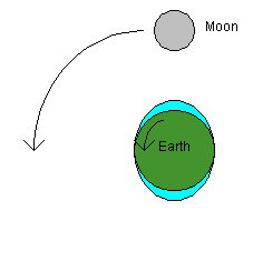
The diagram to the right shows how the moon causes tides on Earth.
In this diagram, you can see that the moon's gravitational forcepulls on water in the oceans so that there are "bulges" in the ocean on both sides of the planet. The moon pulls water toward it, and this causes the bulge toward the moon. The bulge on the side of the Earth opposite the moon is caused by the moon "pulling the Earth away" from the water on that side.
If you are on the coast and the moon is directly overhead, you should experience a high tide. If the moon is directly overhead on the opposite side of the planet, you should also experience a high tide.
During the day, the Earth rotates 180 degrees in 12 hours. The moon, meanwhile, rotates 6 degrees around the earth in 12 hours. The twin bulges and the moon's rotation mean that any given coastal city experiences a high tide every 12 hours and 25 minutes or so.
HOW TIDES AFFECT THE FISHING INDUSTRY
Tides raise and lower the water level approximately two times per day and affect where fish are located and how they feed. When deciding when to fish, keep in mind that timing of a high or low tide changes daily and is also different for each coastal area.
A shallow area that might hold fish and may be a good spot to fish during a high tide, might be a bare mud bank during low tide conditions. And a slough (a slight depression in the bottom) that might be perfect for bottom feeding fish during a low tide, might be too deep and difficult to fish on a high tide.
Running tides (rising or falling) are best since they cause fishing bait to move and promote active feeding among coastal fish. Changing tides, time of day and location are also important when you're fishing in brackish water—coastal water that's a mix of salt water and fresh water and contains saltwater and freshwater fish. Brackish water is found in most tidal creeks and rivers along coasts and is highly affected by tidal movements.
In general, the best fishing is almost always on a rising or falling tide—not dead low or dead high tide when there is little or no water movement.
Determining the best time to fish requires checking on many fishing factors and outdoor conditions. Read the local newspaper and visit with folk at a local tackle shop to get accurate tide information.
Fish are creatures of habit. They move because they have to move (the water is running out from under them) or because their food is moving. Fish migrate up and down the coastal waters every spring and fall because they are following the bait fish. If the baitfish linger in an area because of an unusually warm fall, the bigger fish will linger as well.Just as water temperature makes fish move each season, the tides in any given area of the country make fish move every day. They are the key to catching fish and catching them every day. If you know the tides, you can generally catch fish somewhere on that particular tide.
The time at which different types of fish move and feed depends on the tide. The saltwater coast line of the Southern and Southeastern United States has many rivers and creeks coming through saltwater estuaries, oyster beds, and marshes to reach the Atlantic Ocean and Gulf of Mexico. These estuaries and marshes are the very beginning of the marine food chain for all species of fish. On a high tide, water will flood the marshes, covering acres and acres with as much as two feet or more of water. Crabs and small baitfish will follow that rising tide to feed on in the shallows. Larger fish, such as redfish, flounder, drum and trout will also follow that rising tide in to feed on these baitfish.
High tide in the coastal marsh finds large schools of small redfish on a shallow flat, roaming in search of forage. Individual large reds can be seen tailing as they root for crabs and other crustaceans in the mud.
As the tide begins to fall, the water coming off these flats begins to funnel into small channels, leading into larger channels and eventually into the creeks and rivers. Fish sense the dropping water and will move out with the tide to deeper water. These tidal outflows to deeper water are where fishing can be great.
As the water drops, oyster bars become visible, and the juvenile crabs can be seen scurrying about the shells. Take note of the life that abounds on the oyster bars. They almost tend to be a self contained ecosystem, with each resident depending on the other for survival.
In country and estuary fishing, a high outgoing tide means fish will be concentrating in the tidal outflow areas and moving to deeper holes in the creeks and rivers. In winter Seatrout move into these deep holes. Summer finds the redfish and flounder in the same holes.
In country and estuary fishing, a high outgoing tide means fish will be concentrating in the tidal outflow areas and moving to deeper holes in the creeks and rivers. In winter Seatrout move into these deep holes. Summer finds the redfish and flounder in the same holes.
RED TIDES
Harmful algal blooms, or HABs, occur when colonies of algae—simple plants that live in the sea and freshwater—grow out of control while producing toxic or harmful effects on people, fish, shellfish, marine mammals, and birds. The human illnesses caused by HABs, though rare, can be debilitating or even fatal.
While many people call these blooms 'red tides,' scientists prefer the term harmful algal bloom. One of the best known HABs in the nation occurs nearly every summer along Florida’s Gulf Coast. This bloom, like many HABs, is caused by microscopic algae that produce toxins that kill fish and make shellfish dangerous to eat. The toxins may also make the surrounding air difficult to breathe. As the name suggests, the bloom of algae often turns the water red.
HABs have been reported in every U.S. coastal state, and their occurrence may be on the rise. HABs are a national concern because they affect not only the health of people and marine ecosystems, but also the 'health' of local and regional economies.
But not all algal blooms are harmful. Most blooms, in fact, are beneficial because the tiny plants are food for animals in the ocean. In fact, they are the major source of energy that fuels the ocean food web.
A small percentage of algae, however, produce powerful toxins that can kill fish, shellfish, mammals, and birds, and may directly or indirectly cause illness in people. HABs also include blooms of non-toxic species that have harmful effects on marine ecosystems. For example, when masses of algae die and decompose, the decaying process can deplete oxygen in the water, causing the water to become so low in oxygen that animals either leave the area or die.
The Currents
The current in the Gulf of Mexico is called the Loop Current. The Loop Current is an area of warm water that travels up from the Caribbean, past the Yucatan Peninsula, and into the Gulf of Mexico. The current is also known as the Florida current as it flows through the Florida Strait, into the Gulf Stream, and heads north up the eastern coast of the U.S.
From the south, the Gulf of Mexico is fed by a current of warm water from the Caribbean, which enters the Gulf between Mexico's Yucatan Peninsula and Cuba. This forms the Gulf Loop Current, which curves east and south along Florida's coast and exits through the Straits of Florida.
The Gulf Loop is variable. Sometimes, the current barely enters the Gulf of Mexico before heading towards the Atlantic. At other times, it may travel nearly to the coast of Louisiana before swinging back towards the Florida Strait.
Resources
COMMERCIAL FISHING
Commercial fishing has a long history along the Louisiana Gulf Coast. Le Page du Pratz in his 1758 Histoire de la Louisiane, wrote of observing shrimp being fished in the lakes south of New Orleans using nets from France. Shrimp were first canned commercially in Louisiana as early as 1867 at Grand Terre Island. Shrimping is a way of life and a family tradition in Louisiana extending well back into the 19th century and earlier.
Today, Louisiana is second only to Alaska in terms of both tonnage and dockside revenues from commercial fishing. Seven of the top 50 seafood landing ports in the United States are in south Louisiana. Three of these ports, Empire-Venice, Intracoastal City and Cameron, are in the top 6 seafood landing ports nationwide. Nearly 75 percent of the fish landed in the Gulf of Mexico come through a Louisiana port.
The importance of estuarine-dependent species to the commercial fish landings varies by region, depending greatly on the strength of the estuaries. For the Gulf of Mexico, the top estuarine-dependent species constitute 89 percent of the value of landings, whereas California and Pacific Island landings are only 13 percent estuarine-dependent. As of 2008, the region boasted 1.3 billion pounds of commercial fishery landings per year, yielding a value of $662 million. Eighty-three percent of U.S. shrimp landings and 56 percent of U.S. oyster landings are in the Gulf of Mexico.
The Gulf Coast is widely regarded as one of the top ten recreational fishing spots in the world. More than three million recreational fishers take part in over 24 million fishing trips each year. Annual expenditures related to recreational salt water fishing generates more than $12 billion in sales including equipment, bait, boats (including charter boats), food, lodging and transportation, and supports more than 113,000 jobs throughout the Gulf region. The Gulf of Mexico accounts for over 40 percent of all U.S. marine recreational fishing catches.
The Seasons
When you're fishing on the Gulf Coast, the weather and seasons will affect what you catch. During winter it is easier to catch bull redfish, and in spring it is easy to haul in Spanish mackerel. Summer is when fish seem to do the most biting, with king mackerel, red and white snapper, grouper and amberjack in abundance. During fall, plenty of fish are still biting, including triggerfish, scamp and wahoo.
The Weather
During a storm or hurricane , strong winds push the water and make the tide higher or lower.
Snook are warm water fish that move south as the fall and winter months approach. Snook cannot survive very long in water colder than 55 degrees. Massive fish kills on the southern tip of Florida have occurred in years past because of a sudden drop in water temperatures caused by a particularly strong cold front. The water today was around 60 degrees; any snook in the area should have been headed south a long time ago.As the tide began moving out, Blake managed a small gag grouper on jig head tipped with shrimp. Juvenile gags are often seen in the Intracoastal Waterway (ICW), but not at this time of year.
Snook are warm water fish that move south as the fall and winter months approach. Snook cannot survive very long in water colder than 55 degrees. Massive fish kills on the southern tip of Florida have occurred in years past because of a sudden drop in water temperatures caused by a particularly strong cold front. The water today was around 60 degrees; any snook in the area should have been headed south a long time ago.As the tide began moving out, Blake managed a small gag grouper on jig head tipped with shrimp. Juvenile gags are often seen in the Intracoastal Waterway (ICW), but not at this time of year.
